
Content
Educational programs, such as short courses and web training, are periodically offered through NebraskaView and can be arranged for groups of 6 or more. Please feel free to contact us for more information.
Geospatial Educational Resources
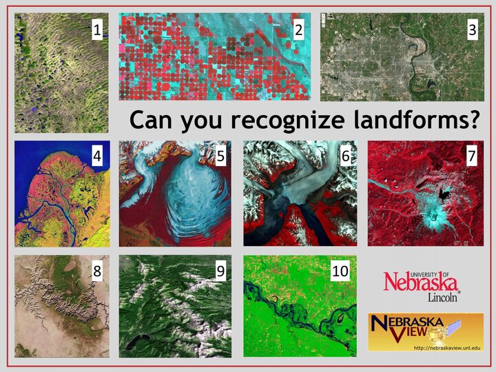
Landforms Quiz
NASA created and NebraskaView modified quiz uses USGS Earth As Art images to challenge middle school students to recognize mountains, rivers, glaciers and other land forms as they are viewed with Landsat satellites.
Landsat Science page
NASA website providing information on the Landsat satellites, news, data, galleries, and education.
https://landsat.gsfc.nasa.gov/
Interactive Education Module on Climate Change Effects
The US Forest Service's Climate Change Resource Center (CCRC) has released a new interactive online education module on climate change effects on forests and grasslands. The CCRC's first education module provides a basic climate change foundation, and this new module builds on that foundation, examining climate change effects around the country.
https://www.fs.usda.gov/science-technology/climate-change
Canadian Centre for Remote Sensing Tutorials
Concepts of Remote Sensing, including applications in agriculture, forestry, geology, hydrology and meteorology. Appropriate for High School and Undergraduate students.
Remote Sensing Tutorials - Natural Resources Canada
The GLOBE Program
Global Learning and Observations to Benefit the Environment (GLOBE). A worldwide hands-on, primary and secondary school-based science and education program. GLOBE promotes and supports students, teachers and scientists to collaborate on inquiry-based investigations of the environment and the Earth system working in close partnership with NASA and NSF Earth System Science Projects (ESSPs) in study and research about the dynamics of Earth's environment.
NASA Earth Observatory
Imagery and applications related to atmosphere, oceans, lands, energy, and life.
Remote Sensing Image Galleries
EarthNow! Landsat Image Viewer
EarthNow! displays data received from the Landsat 7 satellite as it passes over North America.. When a Landsat satellite passes within range of the ground station at the USGS Center for Earth Resources Observation and Science (EROS) Data Center in Sioux Falls, SD, images are down-linked and displayed in 'near-real' time. When no satellites are within range, the most recent pass is displayed. This fascinating web site lets us 'see' what the satellite is seeing. A great site for educators, scientists, or anyone with an interest in satellite imagery.
https://earthnow.usgs.gov/observer/
USGS Earthshots
Satellite Images of Environmental Change
https://earthshots.usgs.gov/earthshots/
MODIS Gallery
NASA MODIS satellite imagery from February 2000 to the present.
Free Viewer and Software
Google Earth
An extensive map archive combined with Google Search capabilities allows searching for and viewing satellite imagery, maps, terrain and 3D buildings.
MultiSpec
Remote sensing application with many features for research and education.